On 23 April 1938, the Daily Telegraph and Morning Post published this article by Alec Riley, alongside two of his photographs from a return visit to the Gallipoli peninsula. The piece appeared just before Anzac Day that year, timed to coincide with a new Gallipoli exhibit at the Imperial War Museum to which Riley had contributed.
In it, Riley revisits the beaches and battlefields of Helles – places he had known as a soldier in 1915 – and describes what he found there more than two decades later.

Gallipoli under Tranquil Skies
Revisiting Beaches and Battlefields with the Eye of an Old Campaigner
By Alec Riley
On an April morning in 1915, British soldiers landed on the beaches of Helles; and although the survivors of those landings, subsequent battles, and months of occupation cannot forget their adventures, their recollections of the country itself are fading. Nearly twenty-three years have passed since most of them saw it.
My first glimpse of Gallipoli since 1915 was from a steamer approaching the Dardanelles. Across the blue waters were the light, grass-topped cliffs of Helles and Achi Baba’s distant slopes. The Cape, “W” and “V” Beaches and Sedd el-Bahr Fort were there in their old familiar forms. The River Clyde had gone, there were no lighters lying off the beaches, no signs of activity on shore, no smoke rising from the hill; but there were two new landmarks: the white lighthouse on Cape Helles, and on Guezji Baba, the obelisk of the British Memorial, which the steamer saluted with three siren blasts.
Identifying Dug-Outs
From each of several famous viewpoints on Helles Ridge the inland prospect is similar: Achi Baba, five miles distant, spreads his green and attractive terraces along the horizon, dominating the apparently featureless central country. By a track through olive orchards on the rear slope of Helles Ridge, I descended to Morto Plain, crossed it, and made my way up to Pink Farm. A short walk from Pink Farm took me to Twelve Tree Copse Cemetery, where three grassy terraces command a wide panorama of central Helles.

Survivors of countless digging parties may be interested to know that the average depth of their trenches was four feet when I saw them last, and that it was possible to walk a few yards in parts unchoked by weeds, brambles or young fig trees. Even certain lines could be identified from memory or a map, but others had changed beyond recognition.
Here and there I made out the grassy blocks of traverses and the hollows of trench recesses. Many dug-out sites were patches of sandy soil with tufts of grass, but some of them could be identified by local landmarks.
In 1915 we could walk along the Western Mule Track to the Ravines and Fusilier Bluff, through Sauchihall Street to White House, to Leicester Square, via Oxford Street, Piccadilly Circus and Regent Street; we could follow Nelson Avenue, St. Vincent and Argyle streets, or reach Birdcage and Barricade from Essex Knoll or Hampshire Cut. We knew, also, the two Australian lines, Oldham and Wigan roads, the Ghurka Mule Trench and Ardwick Green. Much of the story of Helles was told by its trench-labels; but these trenches, now, are unnamed and silent ditches.
Littered with Relics
Although copper, brass and the large forms of war material have been cleared away, innumerable relics survive. In certain areas the ground was littered with what were known as “shell-cases,” bullets, clips, odd rounds of S.A.A., shrapnel-balls and fragments of bombs, with tins, tunic and trouser buttons, and such details as a broken tooth-brush and the metal frame of a small mirror. There were shards of that popular pottery which is stamped “S.R.D.”; and a jar-neck with cork intact told its story of deliberate destruction—and waste.

The first of my return visits to Helles included June 4. Recalling some of the events of June 4, 1915, I allotted that day to Achi Baba and places of interest within reach of the Krithia road.
This road descends from Sedd el-Bahr to Morto Plain, and rises, near Skew Bridge Cemetery, to the spur-top between Krithia Nullah and Achi Baba Nullah, where it is sandy and rutted, but level for some distance and parallel to the track of 1915. It crosses Eski Line and then Redoubt, where a left-hand path leads to Redoubt Cemetery.
The Vineyard, a small area of flourishing but untended vines, 300 yards from Redoubt, was more fruitful in grenades than grapes in 1915. Here I had difficulty in penetrating close, overgrown trenches, where the air was stifling, and where bombs with short fuses lay in soft earth. The last British firing-line ran through the Vineyard. Like that of the Turks, it is shallow and bushy.
A Derelict Lighter
Achi Baba lies almost half-way between Dardanelles and Aegean, his spurs and terraces extending and declining in all directions. I recalled restless nights and hopeless dawns in the country below; and noisy days such as that other June 4 when the hill was shrouded in the smoke of blasting shell-fire. It was easier, however, to remember the lighter misfortunes of a time when I hoped that my stay would not last much longer–though I feared that it might.
My recollections of Achi Baba on this later June 4 are those of a hill-top silence, only broken by birds and the soft rustle of leaves; and of a hillside farm, where kindly Turks brought water and refreshment, while they invited me to rest in the shade of the olive trees.
I made an expedition to the beaches of Western Helles, by way of Pink Farm and Great Gully; following the winding gully to its shallow extremity near Krithia, inspecting Fusilier and Gurkha Bluffs with their surroundings, and descending “Y” Ravine to its beach. This broken and scrubby country was littered with relics; and, on the slopes of “Y” Ravine, I found traces of the primitive shelters of 1915. Beyond the rocky foot of Ghurka Bluff I came to the shore-end of Bruce’s Ravine—rugged enough in the past by even wilder now.
From the far end of a path along the spur, between coast and ravine, I surveyed Gully Beach. To my left was Great Gully, with its scrubby slopes and yellow curving cliffs; to the right, on the spur-shore and close to the concrete and rusting iron of a broken pier, lay a derelict K lighter which ran aground on the night of the evacuation. There were traces of dug-outs on the face of the spur-point, but only a sandy and weedy bank, behind the beach, marked the site of what I knew as an overworked Field Ambulance.
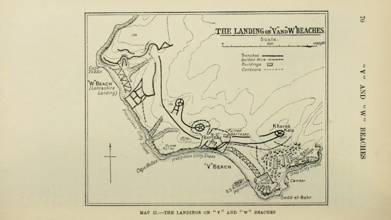
I planned a further walk, to cover “W” and “V” Beaches. The first objective was Lancashire Landing Cemetery, 300 feet above the beach and 1,000 yards behind it, where the gate-piers bear these words: “The 29th Division landed along the coast on the morning of April 25th, 1915.”
Lancashire Landing, or “W” Beach, lies between Tekke Burnu and the N.W. end of precipitous and cliffy slope which continues to Cape Helles, and it is backed by an irregular slope and small gully. Surveying the shore from each cliff in turn I looked down upon partially buried lighters and the remaining stones and iron supports of piers.

From the south-eastern cliff I made my way to Cape Helles, where the coast bends eastward sharply, and followed the cliff-line to a point below Fort No. 1 for the best view of “V” Beach.
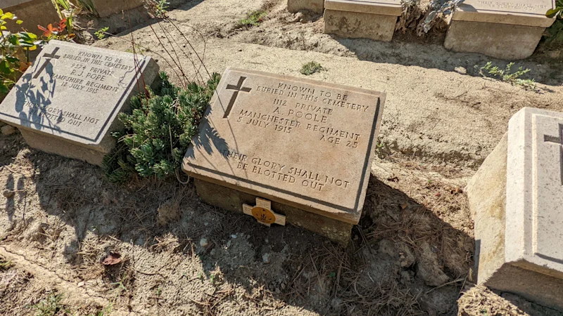
Below me lay the cemetery, a few feet above the sands, with its memorial facing the sea and its gate facing the beach. Then came the low earth cliff, by which “V” Beach is backed, and a central jetty. Near the Old Fort were the remains of the River Clyde pier. Land adjoining the shore had been cultivated; a field near the fort was being ploughed, on the long slope behind the beach, sheep were grazing between old trenches where village children played.
I recalled the River Clyde: her bullet-chipped bows, the shell-holes in her deck, the water in her holds; the broken glass of her screen, and the large ports through which, during the landing, men had passed to gangway and lighters, and many to their deaths—for, in the Cemetery, several headstones bear this date: “April 25, 1915.”
Only the murmur of lapping wavelets disturbed the silence of “V” Beach.
The Shadows Lifted
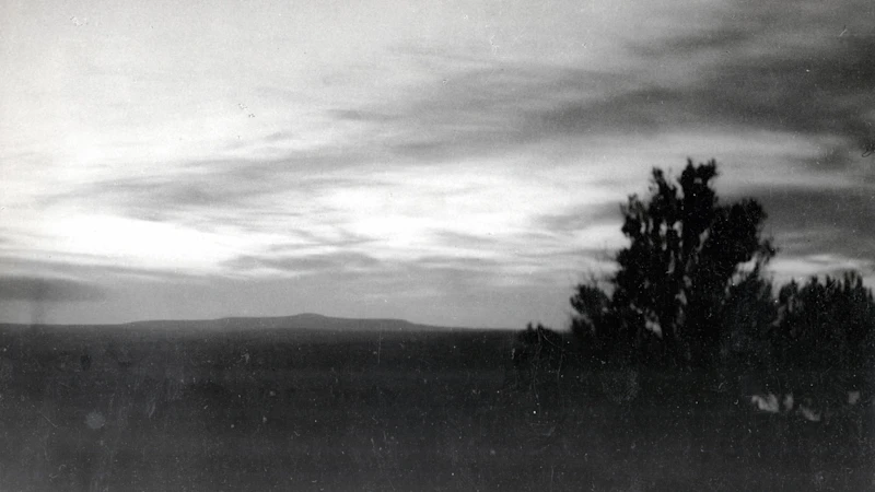
Sunset reddens the Aegean and blackens Imbros and Samothrace, while colours fade from the darkening landscape and stars shine with increasing brilliance. In the cold glare of a full moon Krithia road wavers across hazy contours into shadowed obscurity. The Helles night-choir of howling dogs and hooting owls is augmented by a chorus of bull-frogs. No “strays” whisper over the battlefield, but the echoing sound of a farmer’s gun-shot is strangely familiar.
Grey dawn streaks, mirrored in Morto Bay, widen slowly as they change to pale yellow, gold and red. The olive-trees take shape; and calls of wakening life sound over field and valley. Then, the rising sun floods the early mist with his light, while he turns Achi Baba from grey to green and lifts the shadows from the dark country of the Nullahs.
Source: The Daily Telegraph and Morning Post, Saturday 23 April 1938.
‘Gallipoli Today’
Gallipoli Diary 1915 includes, as an appendix, a detailed account of Riley’s return to the peninsula in the 1930s, together with many more of his photographs: littlegully.com/books/gallipoli-diary-1915